SAND SEARCH ANALYSIS AND REPORT BEFORE FINANCIAL COMMITMENT
 |
| Sub-bottom profiler system |
Sand Search simply means exploring water bodies with the objective of locating areas with sand deposits in commercial quantity, to be exploited by dredging for land reclamation or stockpiling for the purpose of construction.
The importance of sand search in the dredging industry cannot be overemphasized. Sand search has been trivialized in Nigeria’s dredging industry and has resulted in some cases of failed projects due to faulty sand search reports among other factors. Entrepreneurs usually make the mistake of sidetracking professionals in their quest for cheap labour and end up with regrets and huge losses.
In conclusion therefore, a good sand search survey report must among other things provide information as to the quantity of sand available for exploitation based on mathematical formulas and not guesswork ; the quality of sand, usually determined by laboratory sieve analysis for particle size range of the samples ; a co-ordinated bathymetric map of the project area , not a sketch, depicting depths for smooth navigation of the dredger to the sand pit and as a base for determining changes in the sub-bottom topography after dredging ; the exact coordinates of the center point and radius of burrow pits; the distances of the burrow pits to the stockpiling site and a recommendation on the length of dredger ladder required for maximum mining of the deposit from the burrow pits. Professional Hydrographic Surveyors, their fees notwithstanding, should be used for this exercise as a way of avoiding losses, due to inaccurate data acquisition methods. Such post operational losses are by far greater than the Surveyors fees and the report remains an asset for the client. As earlier mentioned, sand search reports determine the success or failure in dredging business and must therefore, be professionally handled.
Contact a dredge consultant to help provide you with professional hydrographic surveyors for a quality sand search report.
The importance of sand search in the dredging industry cannot be overemphasized. Sand search has been trivialized in Nigeria’s dredging industry and has resulted in some cases of failed projects due to faulty sand search reports among other factors. Entrepreneurs usually make the mistake of sidetracking professionals in their quest for cheap labour and end up with regrets and huge losses.
The need for an accurate sand search report before the acquisition of a reclaimable or stockpiling site is very important and is the first step towards carrying out any project in this business. Cases of people rushing to acquire and pay for sites is common, on assumption that sand to be mined is available almost everywhere in the water body. Non-availability of sand in such sites after payment have been made for land, have led to huge losses to such client especially when a non-refundable mobilization/demobilization fee of millions of naira had been paid to a dredging company.
When the proper approach should have been, to first ascertain the availability of sand within the periphery of the proposed dredging site, the quality of such material and the distance from the points of mining to the point of discharge. Such information determines to a large extent the cost of dredging.
Sand search can be carried out scientifically or manually. The scientific approach to conducting sand search surveys involves
The manual approach includes drilling by waterjet procedure, good results is however limited to shallow depths and also has the disadvantage of the geometry of drilling not adhered to by non-professionals who confuse a borehole with a burrow pit and therefore do not ascertain material spread but assumes the availability of sand if a borehole is successful. Volume calculations cannot be based on one point, which necessitates the drilling pattern to either be in a grid format covering the entire project area or in a burrow pit configuration using cylindrical figures. With the former approach, quantity can be calculated from sub-bottom contours while the latter approach allows volume computation by the cylindrical formular.
When the proper approach should have been, to first ascertain the availability of sand within the periphery of the proposed dredging site, the quality of such material and the distance from the points of mining to the point of discharge. Such information determines to a large extent the cost of dredging.
Sand search can be carried out scientifically or manually. The scientific approach to conducting sand search surveys involves
- Bathymetric Mapping for depth information,
- Boring for sample collection and
- Accurate Positioning of proposed burrow pits for dredging from the right spot.
 |
| Sub-bottom profile survey courtesy oceanology international |
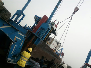
The manual approach includes drilling by waterjet procedure, good results is however limited to shallow depths and also has the disadvantage of the geometry of drilling not adhered to by non-professionals who confuse a borehole with a burrow pit and therefore do not ascertain material spread but assumes the availability of sand if a borehole is successful. Volume calculations cannot be based on one point, which necessitates the drilling pattern to either be in a grid format covering the entire project area or in a burrow pit configuration using cylindrical figures. With the former approach, quantity can be calculated from sub-bottom contours while the latter approach allows volume computation by the cylindrical formular.
 |
| Manual Sand Search |
In conclusion therefore, a good sand search survey report must among other things provide information as to the quantity of sand available for exploitation based on mathematical formulas and not guesswork ; the quality of sand, usually determined by laboratory sieve analysis for particle size range of the samples ; a co-ordinated bathymetric map of the project area , not a sketch, depicting depths for smooth navigation of the dredger to the sand pit and as a base for determining changes in the sub-bottom topography after dredging ; the exact coordinates of the center point and radius of burrow pits; the distances of the burrow pits to the stockpiling site and a recommendation on the length of dredger ladder required for maximum mining of the deposit from the burrow pits. Professional Hydrographic Surveyors, their fees notwithstanding, should be used for this exercise as a way of avoiding losses, due to inaccurate data acquisition methods. Such post operational losses are by far greater than the Surveyors fees and the report remains an asset for the client. As earlier mentioned, sand search reports determine the success or failure in dredging business and must therefore, be professionally handled.
Contact a dredge consultant to help provide you with professional hydrographic surveyors for a quality sand search report.
Comments
Post a Comment